![[Education] Bourses d'études du CNES 2024](https://centrespatialguyanais.cnes.fr/sites/default/files/styles/slideshow_esp_pro/public/drupal/202403/image/campagne_bourses_2024_02_format_site_866_360.jpg?itok=pp1A_ThA)
![[Ariane 6] Où en sommes-nous ?](https://centrespatialguyanais.cnes.fr/sites/default/files/styles/slideshow_esp_pro/public/drupal/202404/image/va262_accostage_ulpm-llpm_bal_231.jpg?itok=VDHd51f8)
![[Transition énergétique] Vers une optimisation de la consommation](https://centrespatialguyanais.cnes.fr/sites/default/files/styles/slideshow_esp_pro/public/drupal/202404/image/miniature_site.jpg?itok=OIH9LYcg)


Centre Spatial Guyanais
Le site du Centre national d'études spatialesx
Les lancements
-

Mission réussie pour VV23
Après une tentative échouée, le lanceur Vega a effectué sa 21ème mission avec succès.
9/10/2023 -
VV23 : Lancement reporté
Le lancement de la mission VV23 initialement prévu pour le vendredi 6 octobre, est reporté au dimanche 8 octobre, 22h36 (Kourou...
7/10/2023 -
VV23 se prépare au décollage
VV23, troisième lancement de l'année, décollera dans moins d'un mois depuis le port spatial de l'Europe. A son...
8/09/2023 -
Ariane 5 au Panthéon des lanceurs européens
Ariane 5 tire sa révérence à l’issue d’une 117e mission parfaitement réussie.
12/07/2023 -
VA261 : Nouvelle date de lancement
Le 117e et dernier vol Ariane 5 initialement prévu pour le vendredi 04 juillet, est désormais programmée pour le 05 juillet.
31/05/2023


Toutes les actus
-
Point de situation conjoint relatif à Ariane 6 | 26/04/2024
Le groupe de travail sur le lanceur Ariane 6 comprend des représentants de la Direction générale de l’ESA, en tant qu’entité responsable du programme Ariane 6 et du système de...
26/04/2024 -
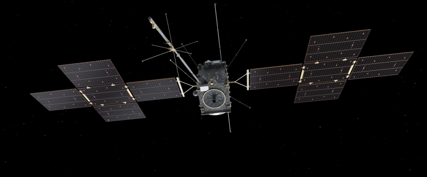
Des nouvelles de JUICE, un an après le lancement
Le 14 avril 2023, le satellite de l’ESA JUICE quittait la Terre à bord d’Ariane 5. Voici un petit récapitulatif de cette première année de voyage !
15/04/2024 -
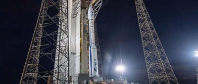
[Ariane 6] Où en sommes-nous ?
La période visée du vol inaugural Ariane 6 se rapproche à grand pas. Point d'étapes sur les dernières opérations de préparation au lancement.
12/04/2024 -
[Transition énergétique] Vers une optimisation de la consommation
D'ici à 2026, 3 centrales solaires photovoltaïques produiront une partie des besoins en électricité du Port spatial de l'Europe. Nous faisons le point avec Jérémy Hedin...
8/04/2024 -
Visite du Président de la République au Port spatial de l'Europe
Dans le cadre de sa visite au Port spatial de l'Europe, le Président de la République, Emmanuel Macron, a visité ce mardi 26 mars, le Bâtiment d'Assemblage Ariane 6.
26/03/2024


Les dernières videos
-

[Ariane 6] Assemblage du corps central
Le Module Supérieur de Propulsion Liquide (ULPM) et le Module Inférieur de Propulsion Liquide (LLPM) ont été assemblés horizontalement au Bâtiment d’Assemblage Lanceur (BAL), le...
5/04/2024 -

[Ariane 6] Arrivée des éléments du modèle de vol
L'étage principal et l'étage supérieur du premier lanceur de vol Ariane 6 sont arrivés à Kourou, le 21 février dernier, à bord du navire hybride #Canopée. Retour vidéo...
28/02/2024 -
Ariane 6 : en route vers le vol inaugural !
A l’heure où le premier modèle de vol du lanceur Ariane 6 arrive en Guyane, les femmes et les hommes du CNES sont fiers du travail accompli. Leurs missions : bâtir, tester et...
20/02/2024 -

[Ariane 6] Déconnexion de systèmes cryogéniques
Retour en vidéo sur la déconnexion des bras cryotechniques d'avitaillement et caissons MANG Ariane6, marquant ainsi la fin des essais combinés utilisant du carburant.
8/02/2024 -

La rénovation du Musée de l'Espace se poursuit au CSG
Les travaux de rénovation du Musée de l'Espace se poursuivent au Centre spatial guyanais. Découvrez à travers ce timelapse, l'avancée des travaux sur la période...
24/01/2024


